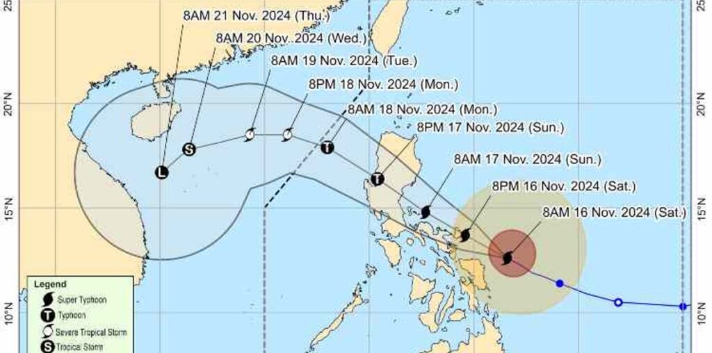
PEPITO (international name: Man-Yi) further intensified into a super typhoon on Saturday morning, November 16, 2024, the Philippine Atmospheric, Geophysical and Astronomical Services Administration (Pagasa) said.
In its 11 a.m. bulletin, Pagasa said Pepito continues to pose a significant threat to the Bicol Region as it intensified with maximum sustained winds of 185 kilometers per hour (km/h) and gusts of up to 230 km/h.
The super typhoon, moving west-northwest at 25 km/h, is forecast to make landfall in Catanduanes on Saturday night or early Sunday morning.
Tropical Cyclone Wind Signal (TCWS) No. 4 has been raised in Catanduanes and the northeastern portion of Camarines Sur (Garchitorena, Presentacion, Caramoan, Lagonoy, San Jose). Areas under Signal No. 4 can expect winds exceeding 118 km/h and up to 184 km/h within at least 12 hours.
Meanwhile, TCWS No. 3, where winds ranging from greater than 89 km/h to 117 km/h may be expected within at least 18 hours, has been raised in the following areas:
Luzon
The eastern portion of Camarines Norte (Vinzons, Talisay, Mercedes, Daet, Basud, San Vicente, San Lorenzo Ruiz), the northern and southeastern portion of Camarines Sur (Sagñay, Tigaon, Goa, Tinambac, Siruma, Buhi, Ocampo, Iriga City, Sipocot, Pili, Cabusao, Calabanga, Bombon, Magarao, Canaman, Naga City, Camaligan), the eastern portion of Albay (City of Tabaco, Malilipot, Tiwi, Malinao, Santo Domingo, Manito, Legazpi City, Bacacay, Rapu-Rapu), and the northeastern portion of Sorsogon (Prieto Diaz, City of Sorsogon, Gubat)
Visayas
The eastern portion of Northern Samar (Palapag, Laoang, Mapanas, Gamay, Lapinig, Catubig, Pambujan) and the northern portion of Eastern Samar (San Policarpo, Arteche, Oras, Jipapad)
Areas under TCWS No. 2, where winds greater than 62 km/h and up to 88 km/h may be expected within at least 24 hours, are as follows
Luzon
The southeastern portion of Isabela (Dinapigue), Aurora, Quezon, the eastern portion of Rizal (Tanay, Pililla, Jala-Jala), Laguna, the rest of Camarines Norte, the rest of Camarines Sur, the rest of Albay, the rest of Sorsogon, Burias Island, and Ticao Island
Visayas
The central portion of Eastern Samar (Dolores, Maslog, Can-Avid, Taft, Sulat, San Julian, City of Borongan), the northern portion of Samar (Matuguinao, Calbayog City, Santa Margarita, San Jorge, San Jose de Buan, Tarangnan, Motiong, Gandara, Jiabong, City of Catbalogan, Paranas, Hinabangan, San Sebastian, Pagsanghan), and the rest of Northern Samar
Under TCWS No. 1, where winds of 39–61 km/h or intermittent rains may be expected within 36 hours, the affected areas are:
Luzon
Mainland Cagayan, the rest of Isabela, Quirino, Nueva Vizcaya, Apayao, Kalinga, Abra, Mountain Province, Ifugao, Benguet, Ilocos Norte, Ilocos Sur, La Union, and Pangasinan, Nueva Ecija, Bulacan, Tarlac, Pampanga, Zambales, Bataan, Metro Manila, the rest of Rizal, Cavite, Batangas, Marinduque, the northern portion of Oriental Mindoro (Puerto Galera, San Teodoro, Naujan, Baco, Victoria, Socorro, Pinamalayan, Bansud, Gloria, Pola, City of Calapan), Romblon, and the rest of Masbate
Visayas
The rest of Eastern Samar, the rest of Samar, Biliran, the northern and central portions of Leyte (Tunga, Pastrana, San Miguel, Matag-Ob, Tolosa, Palo, Calubian, Leyte, Mayorga, Julita, Carigara, Babatngon, Dagami, Jaro, San Isidro, Santa Fe, Albuera, Villaba, La Paz, Palompon, Macarthur, Tabontabon, Tanauan, Merida, Ormoc City, Isabel, Dulag, Capoocan, Alangalang, Burauen, Tabango, Tacloban City, Kananga, Barugo, Abuyog, Javier, City of Baybay, Mahaplag), the northeastern portion of Southern Leyte (Silago), the northernmost portion of Cebu (Daanbantayan, Medellin) including Bantayan Islands, and the northernmost portion of Iloilo (Carles)
Mindanao
The northern portion of Dinagat Islands (Loreto, Tubajon)
(JGS/SunStar Philippines)

