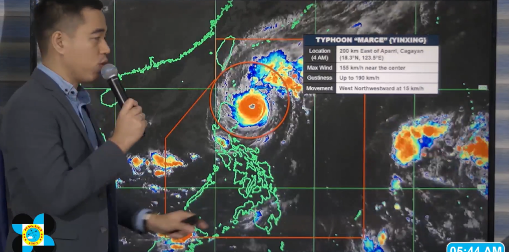
Typhoon Marce continues its approach towards Northern Luzon, maintaining powerful winds and a broad reach that will affect several areas with intense rainfall and gusty winds.
As of 5 a.m. Thursday, November 7, the typhoon was last tracked 200 kilometers east of Aparri, Cagayan, according to PAGASA weather specialist Benison Estareja.
It brings maximum sustained winds of 155 kilometers per hour near its center, with gusts reaching up to 190 kilometers per hour, moving slowly west-northwestward at 15 kilometers per hour, according to the latest update from PAGASA.
In addition to Typhoon Marce, PAGASA is monitoring a potential new weather disturbance east of Luzon. Estareja said satellite data shows a cluster of clouds far east near Guam, which may develop into a low-pressure area within the next day or two. If it strengthens, it could enter the Philippine Area of Responsibility (PAR) over the weekend.
While it’s currently uncertain if this new system will intensify into a tropical depression or storm, PAGASA advises continued vigilance, as it could bring additional rainfall and gusty winds to Luzon, particularly areas already affected by Marce.
“Base naman sa ating latest satellite animation, meron pa rin tayong minomonitor na mga kumpul ng ulap or cloud clusters far east of Luzon, dito sa may parteng Guam. Posibeng may mabuo po dyan na low-pressure area sa loob ng isa hanggang dalawang araw. At posibeng pumasok ng ating Philippine Area of Responsibility over the weekend po yan,” he said.
“Kaya patuloy tayong magmamonitor dahil posibeng maka-apekto muli sa malaking bahagi ng Luzon ang nasabing weather disturbance at hindi rin natin dini-discount na magiging isang bagyo ito sa susunod na linggo,” he added.
Due to Marce, PAGASA has raised Tropical Cyclone Wind Signal No. 4 for Northern portions of mainland Cagayan, including the Babuyan Islands and Northeastern Apayao, where the highest risk of damage is anticipated. Winds of this strength could uproot trees, damage structures, and cut power lines.
“Kapag meron tayong signals No. 3 and No. 4, asahan yung malalakas na hangin na bugso na posibleng makasira ng mga puno at mga pananim, makapagpatumba rin ng ilang poste at mga linya ng kuryente, at posible rin na makasira ng mga ekstruktura yung mga yari sa po sa cogon and pawid, mataas ang chance na masisira ito, ” Estareja warned.
Signal No. 3 has been hoisted over the southern parts of Batanes, remaining areas in Cagayan, Apayao, Ilocos Norte, and Tineg in Abra, forecasting moderate to severe impact from strong winds. Other parts of Northern Luzon, including Isabela, Kalinga, and Mountain Province, remain under Signal No. 2, with Signal No. 1 issued for portions of La Union, Pangasinan, Nueva Vizcaya, and select towns in Zambales and Aurora.
Large areas of Northern Luzon, particularly Cagayan Valley and parts of the Cordillera Region, are expected to experience heavy to torrential rainfall, reaching over 200 millimeters. This volume of rain heightens the risk of flash floods and landslides, especially in low-lying and mountainous areas. Residents are urged to remain vigilant and coordinate with local authorities for possible evacuations.
Additional heavy rainfall warnings are anticipated for Batanes, Ilocos Sur, and Abra, with PAGASA advising residents in flood-prone and landslide-susceptible areas to take necessary precautions.
Strong winds accompanying Typhoon Marce are expected to create rough seas, with waves reaching up to 11.5 meters along the northern coastlines of Cagayan and the Babuyan Islands. Coastal areas in Northern Luzon should also prepare for potential storm surges, as sea levels may rise over three meters in affected areas, leading to dangerous conditions near the shore.
Local government units in Northern Luzon are coordinating closely with the National Disaster Risk Reduction and Management Council (NDRRMC) to ensure preparedness measures are in place, including the suspension of sea travel in affected areas and the potential suspension of classes in highly affected provinces.
Typhoon Marce is expected to continue its trajectory over Northern Luzon, reaching the Babuyan Channel by tomorrow before exiting the Philippine Area of Responsibility (PAR) late Friday or early Saturday.

