November 5, 2024 | 6:30am
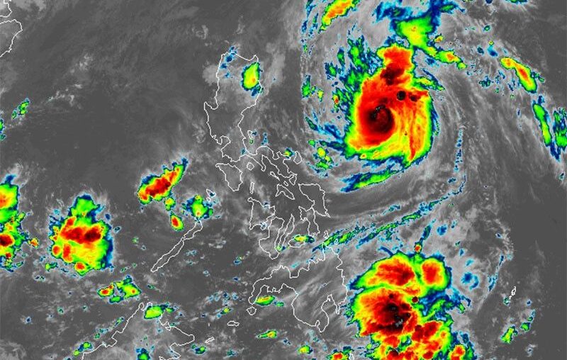
MANILA, Philippines — Severe Tropical Storm Marce (international name: Yinxing) has intensified and is set to become a typhoon on Tuesday, November 5.
Marce strengthened from a tropical storm into a severe tropical storm on Monday night.
In its 5 a.m. weather bulletin, PAGASA said that Marce was located 735 kilometers east of Baler, Aurora.
Packing maximum sustained winds of 110 kilometers per hour (kph) with gusts up to 135 kph, Marce is moving northwestward at 25 kph.
Wing signal
The state weather bureua hoisted Signal No. 1 over the following areas:
- Batanes
- Cagayan including Babuyan Islands
- northern and eastern portions of Isabela (Maconacon, San Pablo, Palanan, Dinapigue, Santa Maria, Cabagan, Tumauini, Santo Tomas, Ilagan City, Divilacan, San Mariano)
- northern portion of Apayao (Santa Marcela, Luna, Calanasan, Flora, Pudtol)
- northern portion of Ilocos Norte (Pagudpud, Dumalneg, Adams, Bangui, Burgos, Pasuquin, Vintar)
Residents of areas under Signal No. 1 could experience minimal to minor impacts from strong winds, ranging from 39 to 61 kph.
Severe winds
The highest wind signal that may be raised due to Marce is Signal No. 4.
The northeasterly wind flow will is expected to bring strong to gale-force gusts over the following areas in the coming days.
- Tuesday, November 5: Ilocos Sur, Aurora, Quezon and Camarines Norte
- Wednesday, November 6: Ilocos Region, Quezon, Camarines Norte, Camarines Sur and Catanduanes.
- Thursday, November 7: Ilocos Region
Sea conditions
PAGASA issued a gale warning for the northern and eastern coasts of Northern Luzon.
It also advised mariners of risky sea conditions, warning that travel poses risks for smaller vessels, such as motorbancas, in the following areas:
- Up to 4.5 meters: Seaboards of Batanes, Cagayan including Babuyan Islands and Isabela
- Up to 4 meters: Northern seaboard of Ilocos Norte
- Up to 3.5 meters: Seaboard of northern Aurora and Camarines Norte
- Up to 3 meters: Remaining seaboard of Ilocos Region; northern seaboard of northern Quezon and Camarines Sur; northern and eastern seaboards of Polillo Islands and Catanduanes
- Up to 2.5 meters: Remaining seaboard of Aurora; the remaining eastern seaboard of Quezon and Bicol Region
- Up to 2 meters: seaboards of Zambales, Bataan, Lubang Islands, Kalayaan Islands, Northern Samar, Eastern Samar, Dinagat Islands, Surigao del Sur, Davao Oriental and Davao del Sur; western seaboard of northern Palawan including Calamian Islands
Track, intensity outlook
Marce is expected to move west-northwest on Tuesday and into Wednesday morning before slowing down and turning west over the Philippine Sea, east of Extreme Northern Luzon.
PAGASA said the storm may make landfall near the Babuyan Islands or the northern part of mainland Cagayan on Thursday evening or early Friday morning. However, changes in the forecast track could shift the landfall point to the Cagayan-Isabela area.
It is rapidly intensifying and is expected to reach typhoon status on Tuesday, likely peaking in strength just before landfall near the Babuyan Islands.
Marce may leave the Philippine area of responsibility on Friday night or Saturday morning, according to PAGASA.

