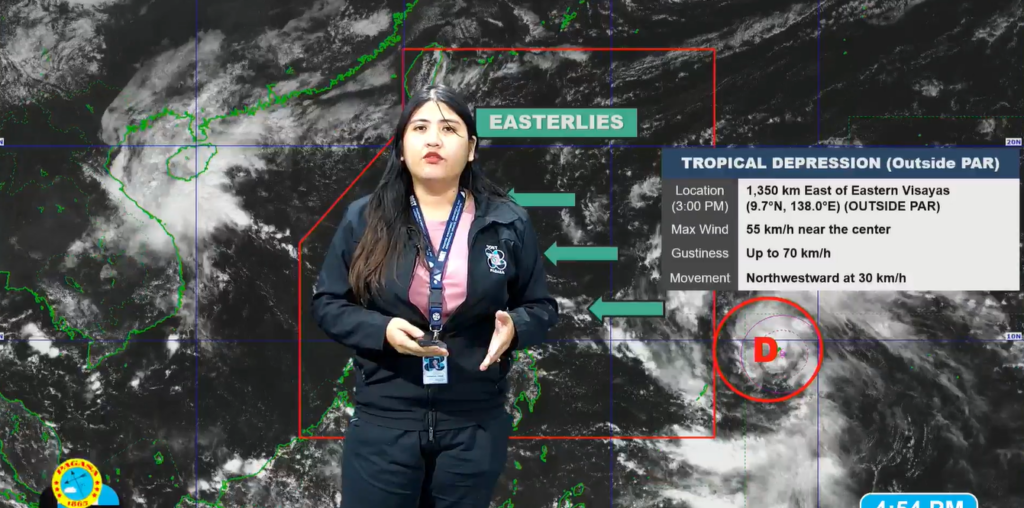
A newly formed tropical depression was located approximately 1,315 kilometers east of Eastern Visayas as of 4 p.m. today, according to weather authorities.
The weather disturbance, currently outside the Philippine Area of Responsibility (PAR), has developed maximum sustained winds of 55 km/h near its center with gustiness reaching up to 70 km/h, and a central pressure of 1004 hPa.
“Yung low pressure area (LPA) na minamonitor natin ay kaninang alas 2 ng hapon ay naging ganap na bagyo na nga at ngayon ay nasa may tropical depression category,” PAGASA weather specialist Veronica Torres reported.
Moving northwest at a speed of 30 km/h, the tropical depression is projected to enter the PAR by tomorrow, November 4, and will be named “Marce.”
Weather forecasts indicate that “Marce” will maintain its northwest trajectory until Tuesday, November 5, before gradually slowing down and veering northward. The forecast for the latter part of the week remains uncertain with possibilities of the cyclone either moving towards Extreme Northern Luzon or remaining over the Philippine Sea east of Northern Luzon.
“Sa bagyong ito, sa kanyang pagkilos may nakikita tayong dalawang scenario. Yung una ay posible nga itong lumapit at tumawid sa northern Luzon o kaya extreme northern Luzon area at yung isa naman ay posible itong lumapit na ating landmass at mag-recurve,” she said.
As it moves into the PAR, Torres said the tropical depression is expected to enhance the northeasterly wind flow across the region, contributing to rougher sea conditions and potential gale warnings over Northern Luzon by Tuesday. The trough of the cyclone could also bring significant rainfall to Extreme Northern Luzon and the eastern sections of Luzon starting tomorrow or Tuesday.
There is a risk of heavy to torrential rains by Thursday (November 7) or Friday (November 8), especially if the cyclone shifts towards a landfall scenario in Northern Luzon.
She said residents in these areas, particularly those in regions prone to flooding and landslides, are advised to monitor updates and prepare for worsening weather conditions.
Mariners are also warned of moderate to rough seas already affecting Northern Luzon’s seaboards, which are expected to deteriorate further as the cyclone approaches.

