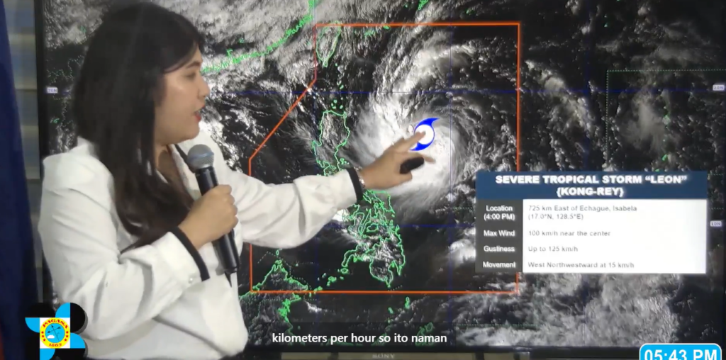
Severe Tropical Storm Leon (Kong-Rey) has strengthened further as it moves over the Philippine Sea, drawing closer to Northern Luzon.
Philippine Atmospheric, Geophysical, and Astronomical Services Administration (PAGASA) weather specialist Veronica Torres reported that Leon is currently situated 725 km east of Echague, Isabela, with sustained winds of 100 km/h and gusts reaching up to 125 km/h.
Moving west-northwestward at 15 km/h, Leon’s storm-force winds extend outward up to 620 km from the center, impacting a broad area.
“Ito ngang si Leon ay further nag-intensify pa nga siya,” Torres said.
PAGASA has issued Tropical Cyclone Wind Signal No. 1 over multiple provinces in Luzon, indicating strong winds ranging from 39 to 61 km/h that may bring minimal to minor damage to life and property.
Areas under this warning include Batanes, Cagayan, including Babuyan Islands, Isabela, Quirino, Nueva Vizcaya, Apayao, Kalinga, Abra, and parts of Ilocos, Mountain Province, Benguet, Quezon, Camarines Norte, Camarines Sur, Catanduanes, Albay, and Sorsogon.
The intensified storm will bring heavy rainfall and severe winds to both coastal and upland areas, with especially gusty conditions anticipated in exposed regions.
Warnings are in place for strong to gale-force winds over Visayas, CALABARZON, MIMAROPA, Bicol Region, Northern Mindanao, and Caraga today. By tomorrow, areas such as Metro Manila, Aurora, and parts of Zambales and Bataan are expected to experience intensified wind conditions.
A a gale warning is also active for the northern seaboard of Northern Luzon. Maritime conditions are set to worsen, with seas expected to reach up to 5.5 meters around Batanes and Babuyan Islands and up to 5.0 meters along the eastern seaboards of Cagayan and Isabela, making sea travel highly risky. Mariners are advised to remain in port until conditions stabilize.
Leon is forecast to continue moving west-northwest today before veering northwest and possibly making landfall on the eastern coast of Taiwan by Thursday (October 31).
There remains a possibility that the storm could track closer to Batanes, with PAGASA warning that the storm may reach typhoon category within the next 24 hours and potentially intensify into a super typhoon by the time it approaches Batanes.
“Itong Batanes ay nasa area of probability kaya hindi natin tinatanggal yong landfalling scenario or yong close approach sa may Batanes area,” Torres added.
The public, especially residents in vulnerable areas, is urged to prepare and heed evacuation orders from local authorities. Those in regions prone to severe flooding and landslides should take immediate precautions.

