28
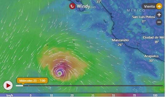
Hurricane Kristy Strengthens into a Category 4 Storm Off Mexico. Where Is It Heading and When?
Maximum wind speeds associated with Kristy are near 150 mph as of Oct. 24, according to the National Hurricane Center

Hurricane Kristy has strengthened into a Category 4 storm as it continues to move out into the Pacific Ocean, but it’s still not expected to impact land.
Kristy first became a tropical storm off the west coast of Mexico on Monday, Oct. 21, and strengthened into a hurricane just over 24 hours later, according to the National Hurricane Center.
As of Thursday, Oct. 24, maximum wind speeds associated with Kristy are near 150 mph as the storm shifts to the west, away from the mainland United States and Mexico, according to the NHC’s latest bulletin.
Forecasters expect “some fluctuations” in Kristy’s intensity on the night of Oct. 24, “with rapid weakening expected to begin” on Friday, Oct. 25.

The storm is expected to “turn toward the northwest then north-northwest” beginning Friday and “through the weekend.”
“By the end of the weekend, Kristy is forecast to rapidly weaken,” according to the forecast discussion.
“This one is moving due westward at a quick forward speed well out to sea, so no concerns for land,” said Brad Reinhart, a senior hurricane specialist at the NHC, according to the Associated Press.
Additionally, forecasters said Kristy will generate swells that will “affect portions of the west coast of the Baja California peninsula late this week and over the weekend.”
These swells, forecasters say, “are likely to cause life-threatening surf and rip current conditions” along the coast.
Meanwhile, no tropical cyclone activity is expected in the Atlantic for at least the next seven days.
The hurricane season ends on Nov. 30; but according to some experts, it may extend a little more than that.

